Day 14: Luray Caverns & Shenandoah Valley, Virginia

It is amazing, the things that are created by the Earth’s processes. While we have an understanding of what can be created in a century or less, the Earth creates something over millions of years. A cave is one of those miraculous Earth-created wonders that most of the world’s population has been unable to appreciate. It’s hard to comprehend something like Luray Caverns that has been building and growing for millions of years, it’s speleothems accumulating at one cubic inch every 120 years.

Dream Lake at Luray Caverns. The bottom is just a reflection of the top. May 22, 2011

I will preliminate the tales of Luray Caverns with something that may set you up for expectations, but you won’t be disappointed. Luray Caverns is one of the most beautiful caves I have ever had the pleasure to be in. It is so highly decorated there is scarcely a wall of limestone that doesn’t have some sort of deposit upon it. Every direction you look is picturesque, it is no wonder that the National Park Service designated Luray Caverns as a registered Natural Landmark.

An antique Luray Caverns sign. May 22, 2011

Luray Caverns was discovered in 1878 by Andrew Campbell of Luray, Virginia. He found some cold air blowing out of a sink hole and came back with more men to begin digging for what he knew had to be a cave. It is confined to a 100 foot thick zone in the Beekmantown Dolomite formation. It has no natural entrance to speak of, other than a very small, impassible hole where Mr. Campbell discoverd the blowing air. Perhaps the lack of openings allowed the cavern to develop so well, and so pristine. It has never been a bat hibernaculum, and no animals call the caverns home.

Fried "cave" eggs of Luray Caverns, Virginia. May 22, 2011 (They are actually broken stalagmites that break and are rounded by water erosion & redepostition)

The cave honestly put me into an emptional swirl, much like my first visit to Carlsbad Caverns in December 2009 (For those of you who haven’t followed me until now, click here for that story). This is only the second time I’ve experienced a cave so beautiful that I had to fight back tears. I know it sounds ridiculous, even I thought it was ridiculous….but it simply evokes that sort of emotion from me. The cave was beautiful, each room arguably more beautiful than the last. There were many unique formations, all with appropriate names.

Luray Caverns' Dream Lake. May 22, 2011
Pluto's Ghost, in the lower right, in Luray Caverns of Virginia. May 22, 2011

Pluto’s Ghost sits in Pluto’s Chasm, something you see several timess through the self guided tour. The audio tour is included with general admission, and is very informative. Titania’s Veil is a beautiful, stark white drapery that will amaze you. Saracen’s Tent is a beautiful drapery formed as a perfect tent, and some cave bacon on the side of it looks exactly like a towel. Dream lake is towards the beginning of the self-guided tour, and although the water is under 2 feet deep it reflects amazingly well and creates a perfect illusion.

In Saracen's Tent of Luray Caverns: A drapery that looks just like a bath towel. May 22, 2011
Titiania's Veil in Luray Caverns of Virginia. May 22, 2011

More intriguing to the average visitot, but cringing to the avid caver and geologist, are the Great Stalacpipe Organ. Boasting the title of the world’s largest musical instrument, this organ is electrically wired to specific stalactites throughout the cavern, each that creates it’s own note. It was created in 1954 by Leland Sprinkle, an electronic scientist at the Pentagon. Yes, the organ plays while you are touring the Cathedral room. It is on an automated system that plays every few minutes. While the thought of having instruments wires to the beautiful speleothems is not something I like to think about, the music is rather beautiful.

The Great Stalacpipe Organ of Luray Caverns, Virginia. May 22, 2011
The mechanism in Luray Caverns that strikes the stalactites, sounding the notes for the organ. May 22, 2011

Another tourist spot is the Wishing Well. All commercial caves have had area like this, where in the uneducated past visitors would throw coins into a deep pool to make a wish. Luray Caverns still has one today, the water turning a blueish green from all of the metals. It is with good cause, though… the coins get to be a foot or two thick every year or so, and the Caverns donates this money to various charities, and have donated more than $400,000 to good causes, cleaning out the pool every year before the coins decay.

The Wishing Well of Luray Caverns, Virginia. May 22, 2011

Don’t believe me yet?  Well here’s what the Smithsonian Institution reported in 1880 of Luray Caverns:
“…it is safe to say that there is probably no other cave in the world more completely and profusely decorated with stalactitie and stalagmite ornamentation than that of Luray”.
Alexander Brand, Jr. of the New York Times said:
“It’s a magnificent cave, the most beautiful I’ve ever seen. Trying to compare your cave to others would be like comparing New York City to the town of Luray”
If you still don’t believe me, look at the pictures at the end of this entry. I took hundreds while  visiting Luray and I had a hard time selecting which ones to share…there were simply too many beautiful places within those caverns. I recommend anyone that is ever in the Shenandoah Valley region to make Luray Caverns a priority stop.

Some local Rootbeer sold at Luray Caverns. Virginia. May 22, 2011
The Stalactite Cafe of Luray Caverns. May 22, 2011

Luray Caverns has more than just caves. It has a Car and Carriage Caravan museum, which houses many unique and rare automotbiles and carriages. I was able to see one of the earliest Dodge vehicles (being a Mopar fan, this was fantastic), and of course many of the early Fords including a Model N (to the love of my Father, who is a Ford man of taste).

A 1906 Ford model N at the Car & Carriage Caravan museum of Luray Caverns. May 22, 2011
The 1915 Dodge logo on one of their early cars. The Car & Carriage Caravan Museum at Luray Caverns.

There are also great views of the Shenandoah Valley, a nice cafe to eat at, several museums, camping and hotels within a short distance. I took the scenic route out of the Luray area, headed to Baltimore to visit my cousin. (Now, whether the country road travel was on purpose or an accident I will not divulge, but you can imagine…)
Since words simply can’t describe how beautiful today was in full, here are some pictures to enjoy. I’ll  see all of you here tomorrow, after I spend a day driving from Baltimore, Maryland to Boston, Massachusetts. A drive that promises to be scenic and interesting. Until then….
-Nicole
Luray Caverns. Luray, Virginia Mayy 22, 2011
Luray Caverns. Luray, Virginia. May 22, 2011
Luray Caverns in Luray Virginia, May 22, 2011. See the cave bacon?
Rimstone in Luray Caverns (only an inch tall or less). May 22, 2011
Luray Caverns. Notice Titiania's Veil in the background. May 22, 2011
A close up of the radiator cap on the Ford Model N. The Car & Carriage Caravan Museum of Luray Caverns, Virginia.
A Ford Model T at the Car & Carriage Caravan Museum of Luray Caverns.
One of the earliest Dodge vehciles, 1915. Car & Carriage Caravan Museum of Luray Caverns, Virginia.
An early Ford Radiator cap. The Car & Carriage Caravan Museum of Luray Caverns, Virginia.
Shenandoah Valley, Virginia- Countryside. May 22, 2011

Day 13, Virginia: Shenandoah Valley & Natural Bridge Caverns

A valley that sits between the Blue Ridge and the Ridge & Valley parts of the Appalachian Mountains, Shenandoah is a gorgeous area full of rivers, farms, and most notably in my case, caves. Most of these caverns lie in the Beekmantown Formation of Ordovician age. Today was a chance to visit a cave of a different region to study it’s speleothem development, and to take in what Shenandoah Valley has to offer.
I had made a game plan for today and the next, but I decided to throw it out the window and go with the flow. I had no idea just how many caverns were in the area and I decided I would see at least two to get a better idea of this area’s karst development. The first cave I decided to see boasted the title of being the deepest cavern on the East coast: Natural Bridge Caverns.

The billboard at the entrance to Natural Bridge Caverns. Virginia. May 21, 2011

The cave tour wasn’t all that long, a guided tour through the caverns, and the cave wasn’t too highly decorated. Moss and bacteria covered many areas, including the limited speleothems that were present. It seems that this area is well known for the cave’s namesake, the Natural Bridge, and thus gains most of the company’s attention. Unfortunate because this cave could be a much better tour if they did a little preservation effort. The cave has two natural entrances, which may have explained the lack of speleothem development due to an increase in air flow.(Or perhaps the overlying lithology that is less permeable?)

The largest of the speleothems at Natural Bridge Caverns in Viriginia. May 21, 2011

I gathered my information and photos with scale from the cave, and more information to research later thanks to an incredibly helpful staff member behind the desk who answered my questions as honestly as he could, and admitted what he did not know. I always appreciate it when a cave tour guide admits they don’t know and offers a venue to obtain the information. The worst is when tour guides start making things up, and luckily this particular man (not my actual tour guide) of Natural Bridge Caverns was honest and helpful enough to do just that.

Some of the few soda straws in Natural Bridge Caverns. Virginia. May 21, 2011

After the cave it was time to do some country driving on my way to my KOA campsite. Shenandoah Valley is, after all, well known for it’s fantastic agricultural landscape nestled between the mountains. The view was gorgeous, rolling fields of green with the mountains standing against the sky in the background. I went to a grocery store to get something to cook at camp, having directions gained from my helpful KOA hostess. This was certainly the biggest grocery store I have ever seen. It was the size of a large Wal-Mart supercenter, yet it was all groceries! I had trouble locating my potatoes….until I realized they had their own section. The produce section of this grocery store is almost the size of the entire grocery store back in Missouri.

The KOA I stayed at for the night. I thought the sign was pretty. May 21, 2011. Shenandoah Valley, Virginia.

My campsite was pretty nice considering I am used to camping in State and National parks. KOA’s always have ample amenities thorughout the camp. My site was in a quiet, forested area near a small brook that trickled along. I was able to cook my food (while holding my breath, it turns out the Jalapenos from this monster of a grocery store were extra powerful and I couldn’t breath near my food while cooking..!!!) and settle down in front of my fire (which consisted of the fire starters, the logs never set….ha ha…) in peace and quiet.

My campsite at the Shenandoah Valley KOA (Firestarted burning, not the logs..ha ha!)

Tomorrow I plan to visit another cave of the Shenandoah Valley, and I have a couple ideas. I don’t know which one I’ll stop at for sure. Sometimes it’s best to play it by ear rather than have it planned. What I do know is that I will have fun no matter where I go. Adventurous spirits don’t find adventurous places, they find adventure everywhere, and anywhere, they go. Until tomorrow’s adventure-
Nicole

The grocery store even had a wide variety of different tomatoes. This was called the heritage tomatoe. It was tasty in my beef, potatoe, onion & jalapeno stir fry. May 21, 2011
The view on the way to my KOA campsite in Shenandoah Valley, Virginia. May 21, 2011

Day 11: Hunting Waterfalls in South Carolina

Waterfalls can teach us all something. The water rushes along it’s riverbed powerfully, rounding the edges of boulders and taking with it anything that happens to land within its grasp. Throughout it’s entire path, the water is never as powerful as when it lets go and falls, absent of boundaries, down the edge of a cliff and into a big pool on the bottom. Sometimes to take life by the horns you literally have to let go.
One of the best tips I could give anyone about traveling is to have big gaps in time not planned. I had thought I would sleep in today, but I found out something interesting as I was checking in to my campsite last night: Waterfalls. South Carolina is full of them. The tantalizing thought of going on a waterfall hunt was too much to resist, so I woke up early and began my waterfall hunt armed with a guide from the Devil’s Fork S.P. camp store.

Heading back into South Carolina after a short "detour". May 19, 2011

Luckily the hang tag I was given for my campsite is also good at many State Parks, so I had no additional park use fees to hunt the waterfalls.  The first falls on the agenda was Twin Falls. I misread the directions and spent an extra 40 minutes of driving along a winding mountain road, all the way into North Carolina. It turned out to be a fortous mistake, and I let the road dictate where I went next. I found butterflies galore, picturesque roads winding through emerald mountain forests, some hairpin turns the very image of those car advertisements. I was even able to be in two places at once, as I got out of my Jeep at the state line of North and South Carolina and put on foot on each side.

Standing in two places at once. My left foot in North carolina, my right foot in South Carolina. May 19, 2011
Grafitti on a rock outcrop in South Carolina along my "detour" route. May 19, 2011

I did manage to backtrack my way to Twin Falls. Located at the end of a rural road in Northwestern South Carolina, the finale of a beautiful 1/4 mile walk through the woods on a narrow path along Reedy Cove Creek.  The water rushes over 70 feet of bare granite falling in two seperate curtains of water (hence why it is called Twin Falls, although it is also known as Eastatoe Falls). The water is cool, and as with all falls it sends a vapor of water into the air making the immediate environment feel a bit cooler than the rest.

Twin Falls, AKA Eastatoe Falls. May 19, 2011
Standing in front of Twin Falls (AKA Eastatoe Falls) in South Carolina. May 19, 2011
A boulder of Granite floating in a pool of water in Granite. May 19, 2011 at Twin Falls South Carolina

After I spent some time at Twin Falls I decided it was time to find another waterfall, so I settled on seeing a few things along the route to my next stop in North Carolina. The next waterfall sits right along Highway 11 in South Carolina, known as Wildcat Branch Falls. It isn’t all that large, but it is rather beautiful and easy to find.

South Carolina's Wildcat Branch Falls May 19, 2011
Flowers at Wildcat Branch Falls in South Carolina. May 19, 2011

Next up was one of the most sought after waterfalls anyone wants to see: Raven’s Cliff Falls. It was described as being a 2 mile hike to see the falls, but also well worth it. Raven’s Cliff Falls is a full 420′ tall, cascading down theblue ridge escarpment to a pool below. (It occurs where the Blue Ridge Province drops 2000′ down to the Piedmont Province for you geology folks) I regularly walk a 6 mile loop at home, so I figured 2 miles would be easy enough. I forgot to include the mountain terraine in my calculations of time. Not only that, but the 2 mile trek only led to a distant view of the falls.  If I wanted to see the falls up close, I would have had to hike another 3+ miles along a route that descends 2000 feet, and reascends the 2000 feet in this distance, adding another 4 hours to my hike.

The trail to Raven's Cliff Falls. May 19, 2011
Azaleas on the trail to Raven's Cliff Falls. May 19, 2011

Never the less, the walk was beautiful with all the Azaleas and various plants in bloom. Every twist and turn in the path led to another view of white, pink, red, yellow and blue blossoms. It was truly late Spring here in South Carolina.

A bloom on the ground on the way to Raven's Cliff Falls South Carolina. May 19, 2011

Unfortunately I did not have time to attempt this additional hike, but I would love to return. If you plan on visiting the Raven’s Cliff Falls area I highly recommend spending the entire day there, if not more. There is a nearby South Carolina state park called Cesar’s Head State Park. The drive is yet another beautiful one, Highway 276 curves through the emerald green forests of South Carolina. There are numerous trails to follow in the 40,000 acres of preserve, an area preserved by the Mills and Moore families of South Carolina until 1981 when South Carolina took possession of the land to be protected for years to come.

Raven's Cliff Falls in South Carolina. May 19, 2011

The waterfalls in South Carolina are countless, yet they all  give in to the world around them. There is always a time to carve your own path through the granite, and a time to fall and let the world take us where we should be. We may get to carve the path to the best falls, but all of us fall from time to time. The success lies in how we view that fall. If we view the fall as our ability to show how strong we can be in the most helpless of times, then we all succeed. True happiness doesn’t come from suceeding in easy times, it comes from surviving in the times we can’t control.
Tomorrow I will be visiting a grand home in North Carolina with a good friend of mine who moved to the area a couple years ago. I have already been there once, and so has she, but we both enjoy it so much we had to see it again. Where will we be going? Well I guess you’ll just have to flow with the water and find out where…..
Until the bottom of the waterfall,
-Nicole

Some butterflies I found on my way to Twin Falls in South Carolina. May 19, 2011
The short 1/4 mile walk to Twin Falls in South Carolina. May 19, 2011
South Carolina's Twin Falls (AKA Eastatoe Falls) May 19, 2011
Raven's Cliff Falls from a distance. May 19, 2011. South Carolina.
The sign that made me decide that a distant view of Raven's Cliff Falls was good enough...for today. May 19, 2011
The trails at Mountain Bridge Wilderness Area, near Ceasar's Head State Park May 19, 2011

Dedication: Day 9 Georgia, Watson Mill Bridge State Park

Nothing worthwhile is achieved without great effort. How you can determine how truly dedicated you are to a cause is by evaluating how long you are willing to try before giving up. Working hard really does pay off, whether it be the intended result or not. Sometimes the result is even better.

The Geology Dept. Banner at the University of Georgia. May 17 2011

Today I slept in a little, with a drive of only 4 hours planned for the day. I was going to head from Savannah Georgia to Athens, Georgia, the hometown of one of my graduate school hopefuls. I had been emailing one of the higher up faculty there in hopes of meeting them while I was here, but unfortunately both of the gentlemen I had been talking to were going to be gone during this part of the summer. Since I had still planned on being in the area I figured it would still be worth a campus visit so I could at least see the campus, the geology building, and the town of Athens and get a feel for the area.

The Hydrangea at the University of Georgia. May 17, 2011

I arrived in Athens about 3pm, and after finding a visitor parking area, I wandered around the campus (with guidance from the campus map board that was stationed near my parking garage). The University of Georgia is quite larger than what I am used to navigating. I don’t know how big Athens really is, but I’m pretty sure that the U of G consumes almost all of it. The campus is really pretty, well landscaped with local plants like blue hydrangea, lilies, and various trees. Every nook and cranny between buildings is well landscaped to include benches and gathering places. It seems no matter where you go you would feel like you have found your own personal oasis. Perhaps this is because it is summer and most of the students and faculty are absent, but I’d like to pretend it is like this all year around.

I dont know why I take a picture of the university stadiums, I don't really follow college sports. None-the-less, here is the University of Georgia's stadium. May 17, 2011

I found the shared Geology/Geography building with little difficulty. The building was open so I went in and wandered. As with all schools, everything was clearly labeled, and those that weren’t were easy to distinguish. The floor with the rocks was the geology floor. The floor with the giant globe would be the geography floor….in general. I was reading the directory and then looking at some pictures when I noticed a familiar name on one of them. It was the very man who was coauthor of the research the man I had been communicating with published. Not even two minutes later I see a walking image of the picture I had just been examining, so I stop and ask if it was indeed him.

The Geography/Geology building at the University of Georgia. May 17, 2011

I had caught him at a perfect time, he says. He was just wandering the building, bored, and considering visiting the library to do some mindless reading. He would be more than happy to show me around and talk to me about what the University of Georgia has to offer. We sat and talked about speleothems from different parts of the world for a time, and then he showed me some of the research they were doing now, opening up the labs and showing me specimens. He told me what type of TA and RA offers they typically make- most of the information I need to know to make a solid decision. I was incredibly lucky to have met him, as he is well known in the field. I had considered for a short moment not visiting the campus since the two men I had been communicating with weren’t going to be there, but I was still determined to get as much information as I can. It turns out the determination paid off, well. That makes 2 grad school potentials down, only 3 more to visit to get a good idea of who offers what.

Some of the local produce I picked up at a roadside fruit stand in Georgia. May 17, 2011
The white peaches I got, first of the season, from a local produce stand in Georgia. May 17, 2011

After my visit with the University of Georgia I headed off to my next campsite: Watson Mill Bridge State Park. On the way to Athens to visit the University of Georgia I had stopped by a local fruit stand and picked up some local produce. I purchased 4 1st-of-the-season white peaches (grown from the standowners orchards), 1 ripe tomato, 1 vidalia onion (from Vidalia, GA, so the real deal), and a few potatoes- all for about $3. You can’t beat that. After stopping by a grocery store to pick up some sausage to slice up, and the leftover jalepeno from my cajun hobo dinner I cooked in Gulf State Park on Day 5, I had a really good dinner in the making.

My tasty dinner made of local produce (and a jalepeno and sausage). May 17, 2011 Watson Mill Bridge State Park Georgia

It turns out the park was absolutely gorgeous. I yet again had chosen the best park I could have in the area. The campsites were large, and the entire area was less than half occupied, there was a quaint wooden covered bridge, the nucleus of the park itself, and trails, waterfalls and more. I had to cook dinner and then eat it while walking on the trails I was so excited to experience them before dark.

My campsite at Watson Mill Bridge State Park in Georgia. May 17, 2011

The place stimulates each of the five senses: The smell of warm cedar. The sound of falling water. The sight of stone mill ruins and a covered bridge. The taste of camp cooked food. And the feel of a cooler, forested climate. It all added up to the fact that I had made the transition from the humid, warm south (which I did love) to the beginnings of the Appalachian Mountains. I was still in the state of Georgia, but something had clearly changed.

The old Mill Ruins you can find if you walk along the trails at Watson Mill State Park in Georgia. May 17, 2011

I couldn’t get enough of the park. I had planned the next day to be leisurely so I stayed there until almost check out time, taking pictures and relaxing in the canopy of the cedars and other trees. I was tempted to stay there another night, but I had already planned to visit another well-acclaimed state park up in South Carolina: Devil’s Fork State Park. I am determined to experience as much of America as I can on this trip, and my dedication had paid off today- It will certainly pay off tomorrow.  I’ll see you there-

Nicole

The covered bridge that crosses the river that runs over a lot of granitic rocks. May 17, 2011 at Watson Mill Bridge State Park
Taking pictures of Watson Mill Bridge in Northern Georgia. May 17, 2011

Luck: Day 8 Part I, St. Augustine, Florida

Luck. It’s one of those whimsical ideas that is often tied to symbolic findings like a four-leaf clover and a bird that drops a little present on your head in flight. Something many don’t truly believe in, yet so many people seem to have it. The Spanish appear to have had luck when they stumbled upon St. Augustine, the lighthouse of the same settlement seems to have had tremendous luck, and even I have had many good hands dealt my way. Luck- Could it be real?

I got up early this morning, a busy day of sightseeing on the books, and headed to the only WiFi access point in Anastasia State Park, located at the beach shop. I settled down in the rising sun with my laptop, uploading pictures of the previous day for all of you to enjoy, when I noticed a few people collecting at the beach. One man was sitting up at the beach overlook deck with a camera on a tripod, and a few people were trickling their ways onto the beach. They weren’t wearing beach attire, nor was it warm enough to swim if they had been. I dismissed it as a group family photo in the making and went about my business. Soon more people began to show up, all toting their DSLR cameras and chatting a little too lively for such an early hour on the east coast. Then someone approached me: “Are you going to watch the shuttle launch?”.

The launch of Shuttle Endeavour as viewed from Anastasia State Park Beach. May 16, 2011.

I almost leapt out of my seat- could it really be that today was the day that they launched the space shuttle Endeavour? It turns out it certainly was- and I was close enough to Cape Canaveral to see if from my vantage on the beach. I was totally unprepared to take such a photograph, so the few that I did get aren’t all that great- but I did get them, and I did get to see it launch. Many thought this was the last launch of the shuttle Endeavour, but according to news articles this was the next-to-last.

If you guys are really hard core about seeing the shuttle launch keep updated on the real “last launch”. Maybe you can find a way to venture out there? Even if you can’t get down to Cape Canaveral, you now know of a great place to camp out and view it from: Anastasia State Park. According to the volunteer who stands atop St. Augustine Lighthouse once a week, this launch view wasn’t as good as it usually is due to some haze. He has been living in St. Augustine since the 1980s, and hasn’t missed a launch since. He even got to work early so he could view the launch from atop the lighthouse. If you are lucky enough, perhaps you can watch the last ever launch of Endeavour from atop the lighthouse.

The St. Augustine Lighthouse. May 16, 2011. Every lighthouse has it's own distinct scheme so that ships can recognize where they are.
Climbing up isn't bad, it's climbing down that makes me nervous everytime. St. Augustine Lighthouse.

The St. Augustine Lighthouse was my first planned trip of the day. I had already visited the lighthouse once, but it is something worth seeing again. The current lighthouse stands 165’ high and has been standing there since 1874. It is built of brick and steel, both crafted here in the U.S., and is the oldest standing brick structure of St. Augustine. When you visit you have to climb 219 stairs to reach the top (sound exhausting, it is!).

A small sample of the stairs of St Augustine Lighthouse. May 16, 2011
The stairs are very pretty to look at. St. Augustine Lighthouse May 16, 2011

Many Florida lighthouses had a lot of trouble staying upright: the soft sands of the coast proved to be a less-than-stable base for the heavier lighthouses of the late 1800’s. St. Augustine has a sturdy layer of coquina for the lighthouse to sit atop, keeping it from the same fate of many other lighthouses in the state. The lighthouse has had several close calls, such as Hurricane Dora and a few other hurricanes, and a couple earthquakes. Fortunately (and perhaps luckily?) the St. Augustine lighthouse has stood tall. (Visit their website at www.staugustinelighthouse.com)

This funny mirror was on the ground. It made for a neat vantage point for a picture. St. Augustine Lighthouse May 16, 2011
The view of Castillo de Sand Marcos as you drive past. May 16, 2011. St. Augustine Florida

It was now time to see to the Castillo de San Marcos, the oldest masonry fort in the continental U.S. Built by the Spanish beginning in 1671, the fort was something to be feared by many enemies. In 1702 British naval & land forces attacked St. Augustine and a not-yet-completed Catillo de San Marcos. The British destroyed the city, but were unable to take on the fort and retreated. In 1728 British troops once again decided to march into St. Augustine, but saw the fort and promptly turned around and left. In 1740 the British governor of Georgia also attacked St. Augustine, but could not capture the fort.

The view of the entrance of Castillo de San Marco when standing atop the fort. May 16, 2011. St. Augustine, FL.

Why was the fort so impenetrable? Was it because of the architectural layout or the cannons? Probably this, and due to the building material provided to the Spanish from Anastasia island, the very rock that the St. Augustine lighthouse stood upon many years later: Coquina.

Close-up of a coquina block at the quarry. St. Augustine, FL Anastasia S.P. May 16, 2011

Geology time: So what is this coquina stuff, anyways? Literally “coquina” translates from Spanish to “tiny shellfish”. Aptly named, coquina is a type of limestone composed of shells, clay and sand that have been chemically bonded together. It may look brittle, but trust me when I say the stuff is tuff, I tested a block of it. So, where did it come from?

The coquina quarry (A historic site) in Anastasia S.P. St Augustine, FL May 16, 2011

Luckily my campsite hosts the spot where the Spanish started quarrying the coquina in 1671. I was able to visit it and learn a bit about the geology of the area. In the Pleistocene epoch there were a series of glaciation/melting patterns that allowed shells, clay and sand to accumulate during the high sea levels, and to cement together when it was exposed to rainwater during times of low sea levels. This developed the Anastasia formation, a formation that stretched from the Northern end of Anastasia Island all the way south to Palm Beach, FL (250 miles long) and is about 330 miles wide, most of it stretching into the Atlantic Ocean.

The wall built of shells. The coquina blocks of the Castillo de San Marco.

The coquina is a very strong rock when dry, so to cut it the Spanish settlers would cut the stone while it was wet, and then allow it to dry for up to a year before incorporating it into the Castillo. It was such a useful building product that one third of St. Augustine’s buildings were made of it by 1764. The Spanish were very (lucky, perhaps?) to have such a building material readily available.

It seems that in the case of my observation of shuttle Endeavour, the long-standing life of St. Augustine Lighthouse and the Spanish settler’s find of the coquina to build the Castillo all speak for the case of luck. It must be real, then…Luck has it. Right?

Let’s look back on the reality of the situation. St. Augustine Lighthouse was built in 1874 to replace a Spanish watchtower built in the late 1500’s. The old watch tower tumbled to the sea in a storm in 1880. It stood for 300 years, a span of time yet to be proven by the “New” St. Augustine Lighthouse. The Castillo de San Marcos was built beginning in the 1670s to replace the 9th (yes, you read right, NINTH!) fort since 1565. It seems that all of these events add up to being in the right place at the right time. It may seem like luck, but it is actually due to ingenuity and being able to see the bright side of things no matter what. The Spanish and other settlers of St. Augustine were smart enough to use what was available to them on their very own Anastasia island, buried beneath the sand dunes and soil (called hammocks). We all know I have had my fair share of mishaps- and the fact that I was able to see something as spectacular as the shuttle launch isn’t due to luck: It is due to my dedication to adventure and putting myself in places where things can, and will, happen.

If you are sitting around waiting for your luck to turn around you aren’t going to get much. Luck isn’t a rabbit’s foot on a keychain or eating black eyed peas on New Year’s Day. Luck is constructed out of your own determination and will. Created by you, for you, by continuing to push forward even after you fail again and again. Don’t let the first 9 fallen forts force you to give up. Look around you, use the tools you have been given, and manifest your own destiny.

Some colorful beetles (or something of the like) at the coquina quarry in Anastasia S.P. May 16, 2011
Chocolates from Whetstone Chocolates of St. Augustine. I had a small snack from here- I was saving my calories (and my money) for a fabulous dinner in Savannah tonight. May 16, 2011
Whetstone Chocolates of St. Augustine. Very good stuff. They even have chocolate dipped bananas, a personal fave.
I'm standing in the watch tower of the Castillo de San Marco. May 16, 2011
The view down a canon if you were getting ready to take down an enemy ship at the Castillo de San Marco in st. Augustine
The sanctuary at Castillo de San Marco, the font on the wall and the altar on the left side of the pic. May 16, 2011
While I toured the Castillo de San Marco National Park officials took precautions to preserve artifacts by vacuumn air out of a case to reduce humidity. May 16, 2011
Where the men would sleep at Castillo de San Marco while on duty (They didn't live at the fort)
Some of the lighthouse prisms at St. Augustine Lighthouse (when you get to the top and are looking at the light, look up!)
I'm about to ascend all of those stairs- all 219 of them! May 16, 2011 St. Augustine Lighthouse
I climbed all the way to the top of St. Augustine Lighthouse…again! May 16, 2011

A Water World: Day 2, Arkansas to Mississippi

Day 2: Arkansas to Mississippi
Water is the most vital thing to life. Not only do we need it for our very survival, but we find it comforting. Millions of us flock to places of aqueous views, and whether we live there or not we all find it calming. The seas, lakes, rivers, waterfalls and springs dominate our culture. Most of our major cities are built near waterways. Water is the essence of our being.

Petit Jean State Park May 10, 2011

Today my friend took me to a place that exemplifies our fascination with water: Petit Jean State Park in central Arkansas. It is a beautiful place full of hiking trails and history, built by the Civilian Conseration Corps starting in 1933, during the Great Depression. Rich in history, and geology, it’s most stunning (and most visited) attraction is a 90′ waterfall that cascades into Cedar Creek Canyon.

Petit Jean State Park-Cedar Falls. The first view when walking up. May 10, 2011

The walk to Cedar Falls isn’t too long, only 2 miles from trailhead to the falls, but it is pretty vigourous. The first 1/2 mile that descends more than 200 feet, climbing down steps made from local rocks by the C.C.C., isn’t the hard part: It’s climbing back up later. I enjoyed it a lot, as sitting in a vehicle for long drives doesn’t offer a lot of exercise so I love to get what I can.
The geology of the area was unknown to me when I entered the park, but I started making some assumptions. My first clue were the trees, many of them obviously several hundred years old, that had grown on top of the rock rubble.

A tree growing on top of a fallen rock. Petit Jean State Park May 10, 2011

The area suggest to me a collapse of a large karst area several hundred thousand years ago. Now, everyone knows how I LOVE karst, so perhaps I try to see it in everything I visit. So, I decided to look it up when I got to camp where I would have wireless internet. Here is what I found:
It turns out that this area was not karst, but it did undergo a similar process as the sinkholes that take place in the carbonates of Missouri and Kentucky. What happened to these sandstone rocks is that the shale, softer and less resistant than the sandstone, was eroded by the water faster and left little support for the sandstone, causing the rocks to tumble. This area is in a big syncline called the Pontoon syncline. For more info on the geology of the area, go to http://www.geology.arkansas.gov/pdf/Geology%20of%20Petit%20Jean%20State%20Park.pdf


I really enjoyed the falls. There is something absolutely serene being in the presence of moving water. You can feel it in the air, and everything seems right with the world. I owe a huge thanks to my friend who took pictures of me, and taught me how to use a lot of the functions on my camera. I am extremely lucky to have a friend who is also interested in photography and we had a great time taking pictures at the falls. She was a gracious host as well and I couldn’t have chosen a better place to start my grand journey! We will have to go camping again soon.
In the afternoon it was time to leave Arkansas and head towards Mississippi. Upon driving EB along I-40 I saw exactly how you can have too much of a good thing. White, Cache, L’Anguille, St. Francis, and Mississippi are all names of rivers, but today they were lakes. At one point the water was so high it was approaching the roadway, and had already risen over the roadway on the WB side. I was lucky enough to squeak by on the EB lanes. They hadn’t closed them, but I imagine if the water isn’t yet receeding they would have had to do so.

Flooding in AR along I-40 5/10/11
The water breached the WB lanes of I-40. 5/10/11
The water, almost level with the roadway, along the EB lanes of I40 in AR. 5/10/11

The Mississippi river took over a large portion of Memphis, reclaiming property that once belonged to the flood plain. Locals had taken over exit ramps as boating ramps, and they lined the new coastline with fishing poles. A few roofs poked out through the water in places.
It is important to remember that many things are vital to our lives, in so many ways, yet there still needs to be moderation. There is a such thing as too much, even of a thing so essential as water. Sometimes we don’t have control over what amount of a good thing we are dealt, but we can decide to use it wisely, and learn from every  moment we get.
The drive through Mississippi was wonderful. I was racing the sun to get to my campsite, the top down on the Jeep, the aromas of pine and honeysuckle breezing through my nose. Mississippi, so far, is a pretty nice looking state. I’ll let you know more about it after I do some more exploring of The Magnolia State tomorrow. Until then-
-Nicole

These flowers were all over Petit Jean State Park when I was there 5/10/11
The stone steps, carved by the CCC, at Petit Jean S.P. 5/10/11
This is me, taking pictures at Petit Jean S.P. in Arkansas (photo courtesy of my friend, Jennifer)


Me, taking a pictureof Cedar Falls at Petit Jean S.P. 5/10/11 (Photo courtesy of my friend, Jennifer)

Day 1: Arkansas

Most of the time when our alarm clock goes off we hit the snooze. It goes off the second time and we either begrudgingly get out of bed, or we hit the snooze again. If you are like me you have to set your alarm clock at least a half hour earlier than you intend to wake up because this process repeats until you can’t fall back asleep without dreaming about your alarm’s incessant call.

The night of a trip is nothing like this. You wake up before your alarm goes off. Only 2 hours until you have to get up. Fall back asleep. The next time your eyes are open, it’s only 1 hour and 45 minutes until your alarm calls. It is one of those rare moments where you anticipate your alarm rather than dread it.

This morning was one of those days.

It was the start of my Grand Adventure tour, to which I call Caves, Waves & Future Paves. Aptly named, as the goals of this 77 day tour is to a) visit potential grad schools b)collect data, photos and other information from a broad spectrum of caves throughout the U.S. for my own research and c) to relax among the worlds wonders (including friends, family, mountains, canyons, geologic marvels and one of my personal favorite: coastlines).

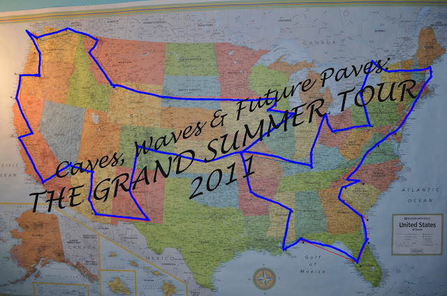
Starting out in Missouri I will be doing two loops: My Eastern loop, which I started today, a short 3 day stop at home, and then my Western loop.(See the map below)


My first stop was just South of the Missouri border in Arkansas: Cosmic Caverns. Along the way I also had a plan of selling some of my stone creations, so I have produced a dozen “cave candle holders” and have them with me. (go to www.geojeep.com/stone-creations to see a picture of it) The Cosmic Caverns gift shop purchased two of them, and seemed likely to want to sell more. I couldn’t have been more thrilled.

Cosmic Caverns Berryville, AR May 9, 2011


The tour of Cosmic Caverns was fantastic. Taking tours on Mondays seems to be beneficial. I was on tour with one couple and the tour guide. The tour guide was very informative and knew a lot about the geology, mineralogy and history of the cave. I was very impressed since I often run into cave tours that know very little about the cave geology. I scribbled an entire page worth of notes in my field book, and noted the size of different items I used as scale so I could reference them later. The tour only costs $14 for general admission, so if any of you are near the area I highly recommend it. There are lots of beautiful formations to take pictures of and the group that works there is very friendly and knowledgeable. If they don’t know the answer they will try to find it for you.


Cosmic Caverns Berryville, AR May 9, 2011


My next stop was at another cave that was only a 30-40 minute drive from Cosmic: Mystic Caverns. Here I was going to actually tour two caves owned on the property: Mystic Caverns and Crystal Dome.

I was the only one who arrived for the next tour, and while they don’t normally allow a tour to go with just one person for safety reasons, the lady allowed me to go because she knew I was doing some research and data collection. Going on tours alone goes nice and fast, and especially if you are someone like myself who has been in enough caves that they don’t have to repeat the same script they have rehearsed uncountable times. I was able to get photographs of almost everything I wanted, with different items of scale.

Mystic Caverns, me in front of a large bell, May 9, 2011

Mystic Caverns is not a very big cave, but it is pretty well decorated- speleothems are in great numbers as compared to the size of the cave itself, although many of them are no longer depositing.

Crystal Dome. May 9, 2011.

Crystal dome is right next to Mystic, and run by the same private owner, but is not known to connect. While the tour route is pretty short the cave itself is much larger. It has a beautiful dome that is covered in draperies, and one of the biggest pieces of cave bacon I have ever seen. (Although the speleothem density is much more sparse than it’s neighbor, Mystic).

Crystal Dome. A large piece of cave "bacon". May 9, 2011


The drive from Mystic Caverns, which is located near Harrison, AR, to Russellville, AR where I was to meet my friend from high school was a beautiful drive. The weather was sunny and warm, so I was able to take the Jeep’s top down and enjoy the air. The view from the top of the mountains was breath taking.

As with any of my trips, I did have an almost crippling mishap. I had put my Jeep top down after touring Mystic Caverns and Crystal Dome and slid my side windows to my soft top under the back of my top, folded down. I was driving south on the curvy, steeply-graded, 7 highway that runs from Jasper, AR to Russellville, AR and I noticed a flash of black in my rear view mirror. One of my side windows had flown out onto the highway into the northbound lane. I pulled over into the nearest driveway, made a u turn and had to stop, mid highway with flashers on, to reclaim my lost window. Without that window, rain would not be a fun weather event. Luckily the time of day I was traveling afforded very little traffic to fight. Close call!

I am now in Russellville at a good friend of mine’s home, enjoying grilled chicken and other good food with her husband and her neighbors. The night is beautiful, and they live right next to a bayou. Tomorrow morning she is going to take me to Petit Jean National Park to see a 90′ tall waterfall, and then I will be treking my way in my Jeep with the top down to Mississippi so I can camp for the night.

It’s funny how we spend life dreading some alarm clocks and anticipating others. This Summer will be a part of my life where every alarm clock will be something I look forward to. I think it will prove to be a great lesson in life. Every day we wake, whether it be to the sun rising and the birds chirping or that incessant buzzing of an alarm, should be cherished. Each alarm allows you to start the journey of a new day.


Until my next alarm clock, here’s a couple more pictures of my journey!

-Nicole

Me, near the Buffalo River
The Buffalo National Scenic Riverway Campground, access to the river next to beautiful bluffs. May 9, 2011.
Looking back at my Jeep standing on the beach of the Buffalo River 5/9/11
I pulled over to look at the Boston Mountains along 7 highway fairly often. 5/9/11
Looking back at the Mountains at a lookout, South of Jasper, AR. 5/9/11

The Grand Adventure: Stats

STATS FOR GRAND ADVENTURE Summer 2011

Days on Road: 74

Miles Traveled:17508

States (and Provinces) Covered: 39 states 1 province (MO,AR,TN,MS, LA, AL, FL, GA, SC, NC, VA, MD, PA, NY, MA, NH, ME, VT, ON, WV, OH, IN, KY, IL, IA, WI, MN, SD, WY, MT, ID, WA, OR, CA, NV, AZ, TX, NM, CO, KS )

Why & Where Did I Go On This Trip?

This is the Grand Adventure tour, of which I call “Caves, Waves & Future Paves”. Aptly named, as the goals of this 75 day tour were to: a) visit potential grad schools b)collect data, photos and other information from a broad spectrum of caves throughout the U.S. for my own research and c) to relax among the worlds wonders (including friends, family, mountains, canyons, geologic marvels, coastlines and, of course, caves). It was a life changing and inspiring journey that I want to share with everyone so that you also feel empowered to travel. I have long believed that the most successful education involves hands-on, in-person experiences, and this is it! Starting out in Missouri I did two loops: My Eastern loop, a short 3 day stop at home, and then my Western loop. (See Map Below)

The Grand Adventure approximate path.

Facet Two. Seeing the World on a Dime: Carlsbad Caverns

Vacation is a time to get away from your normal daily routine. The time off, away from everyday stresses, is suppose to help you relax so you can come back refreshed and recharged. Is this really going to happen if you just spent all of your savings on vacation? No! Does this mean you can’t go on vacation? Certainly not!

Some of the best get aways are exactly that: getting AWAY from the normal, and even away from the costly swipes of your credit or debit card. On the average day an American consumer spends between $30 and $60 on food and drink, alone. (Don’t believe me? Start adding up that $4 coffee, that $8 “value” meal, that $7 alcholic beverage…)Imagine what your daily expenditures are in total. What if I told you that you could spend LESS than that while on vacation? Not only that, but you will be able to see some amazing natural wonders of the world, learn about geology, ecosystems, desert life and more, and camp under a star-filled sky that is unhindered by excessive city lights?

It’s not a story, it’s a fact.

Time to add another facet to your life. Let’s go visit Carlsbad Caverns in New Mexico.

Carlsbad Caverns

There was a time, not long ago (in the first half of the twentieth century) that caves were the thing to go visit. Landowners scoured their property for entrances to these money-making caverns, in hopes of offering tours to the public. Route 66 even boasted Mammoth Caverns in Southern Missouri as one of it’s main tourist attractions. It was in a time when the sciences were just beginning to understand the greater significance of karst topography, and a cave’s delicate geology and ecology. When the emerging science began to show just how delicate these places are, and that it took thousands of years another phenomenon took place that gave these geologists a deep breath of relief. The public started moving away from recreation into a busier, more technologically advanced world. Along with the fall of the mineral springs resorts and other places of natural importance, so too did the business of show caves. It seems America got too busy to go on vacation, or to even find times to relax. Instead we found time for therapists, psychiatrists and more doctor visits. I’m pretty sure these things cost more than a vacation, and are much less enjoyable.

Today, we know a LOT more about caves, and what they have to offer. We know that a single stalactite could take thousands of years to be deposited, and the cavern itself took thousands of years before that to form so that the stalactite even had room to “grow”. Responsible show caves take care to preserve the cave for all of it’s beauty. You won’t find soda straws and stalagmites for sale in cases at the entrance anymore, and the tour guides certainly won’t ask you to take home your favorite cave pearl. Today show caves do everything they can to protect the environment. They add in humidity controlling door locks (double, or more, sets of doors designed to minimize the loss of humidity in a cave), they carefully design pathways as to avoid disturbing any more of the cave than necessary, and they educate the public about the marvels of these underground sanctuaries.

If you go to Carlsbad Caverns you can visit a place just like this, and for next to nothing. This national park charges a mere $6 for entry through the natural entrance to the cave, a tour that can last hours if properly appreciated. Not only do they offer this, but also tours for the more adventurous spirit that go off-the-trail (they book in advance, so plan accordingly). The park itself is full of hiking trails with informative signs. The camping is on the cheap, the food is inexpensive (especially if you decide to grill, like any respectable camper should) and the views are fantastic whether it is day or night. The park is even pet friendly! While they don’t allow animals in the caverns, they do have a pet sitter at the visitor’s center where your furry friend can hang out in the AC with fresh water and food while you explore- for a $5 daily fee. The hiking trails are all free to roam and have fantastic views of canyons and mountains.

If you aren’t the “camping type” then just drive up to the cave’s namesake city, Carlsbad New Mexico, and get a hotel. I stayed at a fair hotel for only $35 a night, that included a free hot breakfast.


To read the first chapter in this series,Facet One,: Click Here


Carlsbad Caverns May 2010


Cave Pearls in Carlsbad Cavern's Rookery (on the Wild Cave Tour of Lower Cave)


The view from up top Carlsbad Caverns National Park


Carlsbad Caverns Dec 2009


The view of a canyon in Carlsbad Caverns National Park


Me, visiting Carlsbad Caverns in Dec 2009


Urban Geology

For billions of years Earth went fairly undisturbed in its natural, non-biological processes. First an active volcanic planet spewed out volcanic rocks, over time sedimentary rocks made their introduction along with the metamorphic. The Earth’s geologic creations determined the terrain of our lands, controlling erosion simply by the contrast of resistant and non-resistant formations. The introduction of life on Earth started affecting the land as early as the lower Ordovician, when small fauna started diversifying and digging through the sediments, disturbing the natural layers. Nothing, however, has changed the landscape of our planet more drastically than that of man. Once we had sedimentary, metamorphic and igneous as the only types of structures on the Earth. Today we have introduced an entirely new type of structure: The Urban rocks.
It doesn’t take a lot of imagination to start seeing a refined form of geology in the urban environment. Concrete is, after all, much like a sedementary rock. In the urban world, such as that which I experienced in my recent trip to Baltimore, MD and the Washington D.C. area, the laws of geology have been utterly ignored. In subway stations, the urban form of a cave, the “sedementary” rocks have been “deposited” long after the creation of the “cavern” itself. The law of original horizontality is largely ignored, and “igneous dikes” of granite intrude downwards into the earth rather than upwards from the mantle.
Often we imagine what the Earth will be like when we leave, wondering how long it will take nature to reclaim what was originally hers. We think of the trees and plants overtaking our buildings built of wood and can imagine it being reclaimed as early as 100 years from time of abandonment. But what about the concrete basements? The large blocks of limestone that have been transported from far away places to build castles and walls? These things, like rocks, have a geologic time scale of reclaiment. The streets, sidewalks, subways and buildings we have created out of our man-made rocks have created a new geology altogether. An urban geology.
What is most interesting about the interruption of the natural geology by the urban geology is the back and forth play. The interplay of natural forces and human created is constantly fluxing. As you travel through the D.C. metro, riding the escalators out of the subway, watch the concrete walls for the new deposits forming along the cracks. Like a cave, the subways of our urban environments are going through a dissolution process to create “speleothems” created by both nature and man. Take a look at a map of the Chesapeak bay: Inner Harbor is a place I love visiting with my cousin when I travel to Baltimore. The bay is much more geometrically constrained than allowed for in nature, contained by concrete blocks and dams that recreated the harbor that favored transport.

One of my favorite things to visit are old, abandoned buildings: namely warehouses and other commercial buildings made of brick, stone or other urban rocks. These buildings are remnants of the industrial revoloution, left to rot for half a century at this point in time, as the U.S. decided to start outsourcing a large percentage of our factory labor. The big concrete parking lots have turned into an urban sedementary unit, that has begun accumulating new deposits on top of it. Give these areas a couple thousand years and you will have natural sedementary units atop an urban sedementary unit. The urban geology even allows for more fractures and passage of water, perhaps an even more complex cave system can develop in the far future. Food for thought: What will metamorphosed concrete blocks look like?
Urban geology is something worth thinking about. It is a subject that has many faucets, and is growing in complexity every day. A combination of architecture, engineering and geology, this phenomenon is going to start growing more interesting every day as the natural cycles of the earth harmonize with the geology created by man.